FOR CONSULTING ARBORISTS

Every rating keeps the four inputs that produced it
ArborProof records a tree risk assessment the way it is actually made: the defects where you found them, the likelihood and consequence categories you selected, and the rating those inputs return. A year later the record still shows the reasoning, not just the verdict.
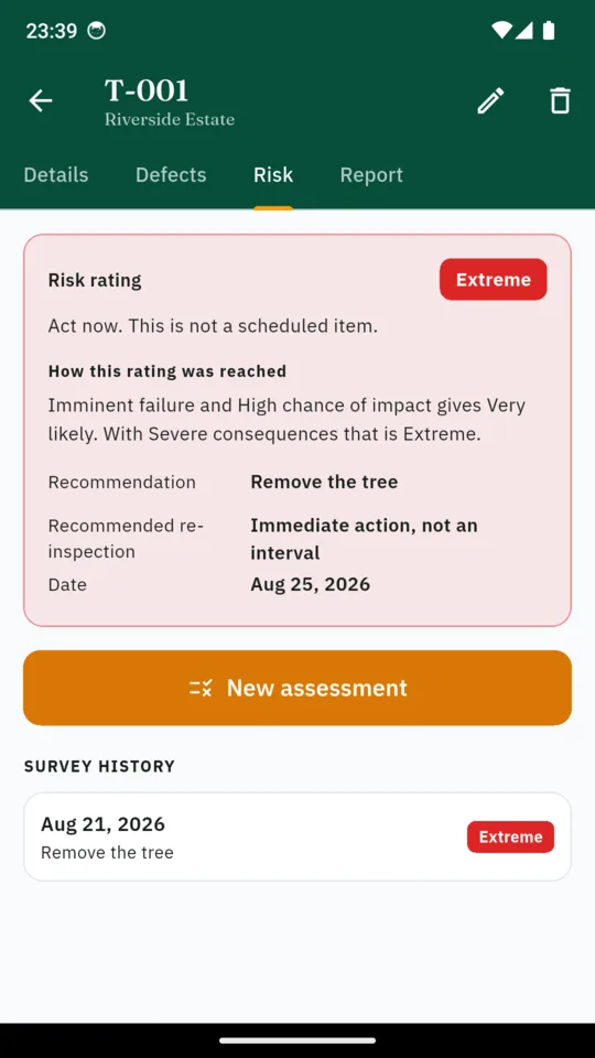
A two-stage tree risk matrix, with the inputs kept
Likelihood of failure is combined with likelihood of impact. That result is combined with the consequences. Both stages are fixed lookups, so a given set of selected categories always returns the same rating, and the screen that shows a rating also shows the four categories behind it.
Choosing those categories is still the assessor's judgement. What the app takes away is the arithmetic and the forgetting, not the expertise.
- 1 Likelihood of failure
Improbable, possible, probable or imminent, for the timeframe you are assessing.
- 2 Likelihood of impact
How often the target under the tree is actually occupied.
- 3 Combined likelihood
The first lookup returns unlikely, somewhat likely, likely or very likely.
- 4 Consequences
Negligible through severe. The second lookup returns the rating: low, moderate, high or extreme.
Defects go where you saw them
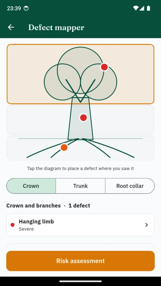
The mapper stores a zone and a defect type rather than free text, because a survey is only comparable across visits if included bark means the same thing every time.
10 types
Crown and branches
Deadwood, hanging limb, codominant stem, included bark, crown dieback
10 types
Trunk and scaffold
Cavity, decay, fungal fruiting body, crack, lean with root plate movement
10 types
Root collar and root zone
Soil heaving, severed roots, girdling roots, collar decay, recent excavation
ArborProof's default re-survey intervals
The app proposes a next-survey date from the rating and sorts every site by whichever tree runs out of time first. These are the app's defaults, not intervals set by any standard. What a site actually needs depends on mitigation, target use, weather and the tree owner's own policy.
What you carry up the drive
Anatomical defect mapper
Tap the crown, the trunk or the root collar on a tree diagram and the pin stays where you put it. Thirty defect types, ten in each zone, each carrying a severity and a photograph.
Two-stage risk matrix
Eight inputs, two fixed lookups, one rating, and the categories that produced it kept on the record beside it.
Root protection area
Radius is twelve times the stem diameter, with the area capped at 707 square metres, which is the same limit as a 15 metre radius. Worked out as you type.
Multi-stem diameter
Enter each stem and the app returns the equivalent single-stem diameter it uses for the root protection area, taking the square root of the sum of the squares.
Re-survey radar
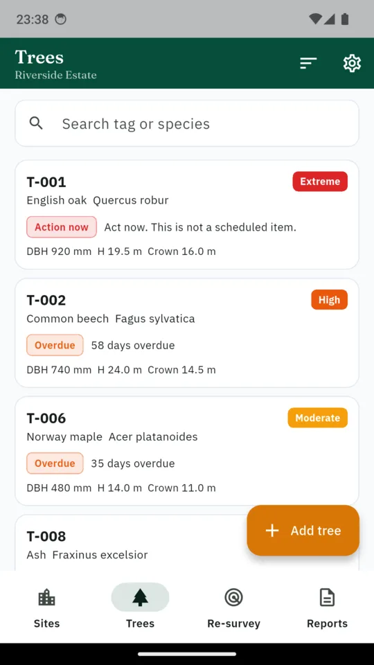
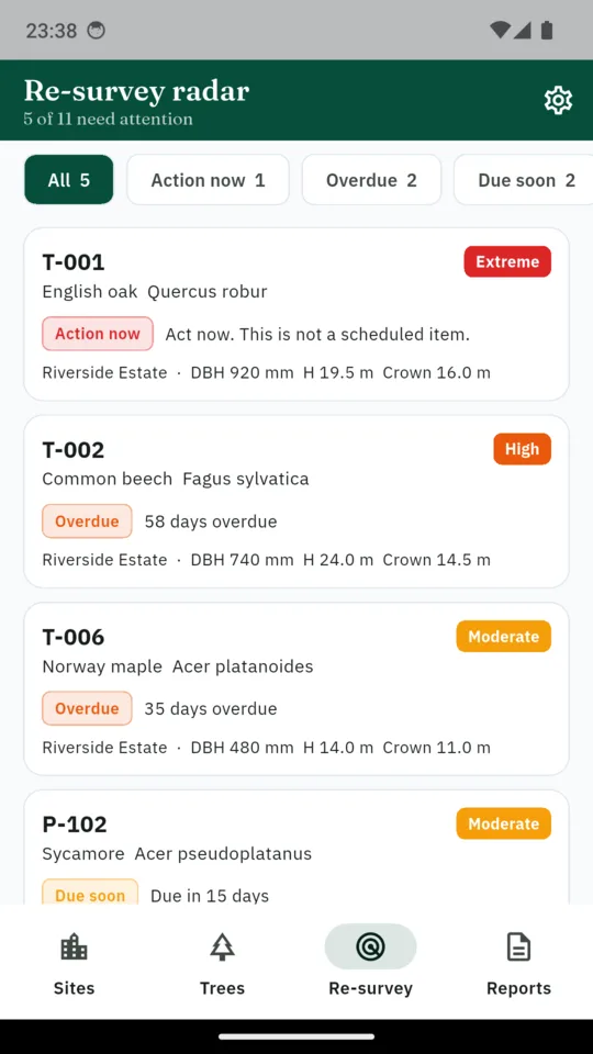
Overdue trees surface first across every site, and a reminder arrives before a tree falls due rather than after.
Survey report
A risk-ranked site summary, a page per tree showing the rating and the inputs behind it, the defect photographs, your recommendation and your signature.
The real screens
How it behaves in the field
- It works with the signal off. Sites, trees, assessments, photographs and coordinates are stored on the device. There is no account and the app does not upload or sync your survey data. A report you choose to share carries whatever is in it, coordinates included.
- A coordinate is optional. Location is taken once, in the foreground, when you ask for it. Every feature works with location switched off.
- The report is built off the main thread, so a large survey does not freeze the phone halfway through an export.
- It states its own limits. The disclaimer below is on the PDF cover page, not buried in a settings screen.
- Ten languages, including Arabic, Hindi, Japanese, Korean and Simplified Chinese.
ArborProof is a record-keeping and reporting tool. It does not diagnose concealed defects or replace the judgement of a suitably qualified arborist. An assessment remains dependent on the scope, conditions and observations recorded by the assessor.
Price
- Fourteen days of everything on install, no card.
- Standard tier covers one site and ten trees and shows a banner. There are no full-screen interstitials anywhere in the survey flow.
- Paying removes the caps and the banner.
- When a trial ends, records already made stay readable. The caps apply to new records.
Questions
Does it work without a signal?
Yes. Sites, trees, assessments and photographs are all held on the device, and there is no account to sign into.
What risk method does it use?
A two-stage matrix: likelihood of failure with likelihood of impact, then that result with the consequences. The categories and the arithmetic are the app’s own implementation, built to record the observations used in professional tree risk assessment.
Can I survey multi-stem trees?
Yes. Enter each stem and the app returns an equivalent single-stem diameter, then the root protection area from that figure.
What is in the PDF?
A risk-ranked site summary, one page per tree with the rating and the four inputs behind it, annotated defect photographs, your recommendation and your signature.
Do I have to share my location?
No. A coordinate is optional and taken once in the foreground. Note that a report you export will contain any coordinates you recorded.
What happens when the trial ends?
Records already made stay readable. New records are capped at one site and ten trees, and a banner appears until you subscribe or buy the lifetime unlock.